AS-BUILT and DIGITAL SURVEY
In this article we talk about one of the fundamental activities to be performed from the beginning of the design phase based on the BIM methodology: the creation of a three-dimensional digital model that represents the construction works and related services being provided during designed.
The reasons that lead to the development of a digital model are many and, depending on the objective, the most suitable software and type of representation shall be indentified. Regardless of the representation chosen, specific design software is always used that can create parametric objects suitable for developing the 3D model and 2D graphics relating to the work being designed. The next step is to develop this digital model during the construction and subsequent maintenance phases to obtain a Digital Twin, which is a dynamic digital representation of the work.
If the use of BIM models for planning and design purposes has reached a good diffusion, what happens during the construction phase? Are we developing the digital model and finally freeing ourselves from spreadsheets and PDFs? Are we starting to manage and transform our work and the sector itself through the use of the data made available by the use of new technologies?
There is now a rapidly expanding ecosystem of tools and technologies that help implement this potential. New start-ups are announced each month that are using AI, Machine Learning, Robotics, VR / AR and other cutting-edge technologies to change traditional business methods and models.
In this context we introduce the Digital Survey. The survey and constant updating of the data collected during construction marks the transition from the BIM model to the Digital Twin. The survey activity in the field makes it possible to exploit the data obtained with new technologies to constantly develop the 3D model and 2D graphics relating to the building.
What is the Digital Survey
The Digital Survey consists of the constant survey of the built works, carried out through geometric verification and by updating the data collected both during construction and at the end of the works. The aim is to obtain the digital processing necessary for the final representation of the building. When the updating of the graphic representation is completed, the As-Built model is processed, which, once completed with the data, will be sent to the Client ready for the maintenance phase.
From the Digital Twin thus obtained, it is possible to learn the precise positioning of all structural, mechanical, hydraulic and electrical components, to interrogate the elements and get all the information useful for the management of the building, thus laying the foundations for each future operation.
Another important application of this activity consists in verifying the correspondence between the project and the built. During the construction phase of a work, the As-Built model is constantly and frequently updated as the work continues, minimizing the risk of errors and unforeseen events.
The methodologies
To create an As-Built 3D model you can follow two different paths. The first strategy consists in updating the BIM model of the project, integrating it with all the elements built concretely. The second method involves the creation of the model starting from the collection of data relating to the geometry of the building through appropriate survey instruments.
The digital technologies available suitable for the Digital Survey are many, as well as the tools available: you can start from the 3D Laser Scanner to move on to the Drone, the 360 Camera, the Tablet / Smartphone and finally to the futuristic Hololens or Smart Glasses such as example the Magic Leap.
This instrumentation can be grouped into 2 broad categories based on the activity they carry out: the geometric survey and verification of the realization with interrogation of the model. The first category includes the 3D Laser Scanner, the Drone and the 360 Camera, while the second category includes Hololens or Smart Glasses. The tools that can belong to both categories are Tablets and Smartphones.
Surely the 3D Laser Scanner is one of the most advanced tools for creating and / or verifying an As-Built model. The instrument is able to measure the built in a simple, fast and accurate way. This equipment scans the space through a laser creating a digital cloud of points which is then used as a basis to verify what has been modeled in the design phase or to create the digital model of the product. There are 2 types of 3D scanners: mobile and stationary. The mobile scanner differs from the stationary scanner especially in terms of its ease of use and speed. Records distances up to 100m with an accuracy of 1.0 / 0.5cm relatively quickly. The stationary scanner, on the other hand, needs to be set up and calibrated at regular intervals and therefore takes longer to use, but is much more accurate; in fact, with this instrument it is possible to obtain an accuracy up to 0.1 cm. In combination with the drone, entire buildings can be easily detected in their entirety by detecting even the parts not easily reachable with the Laser Scanner.
The 3D survey allows for better dimensional accuracy and greater information density, reducing the possibility of making mistakes and giving the possibility of detecting even very large buildings or buildings with many details (such as in historic buildings), which are difficult to process through direct methods.
Laser Scanner Survey and reconstruction of the digital model of a social housing complex in Triest.
To support the geometric survey, the shooting of 360 ° panoramic images can be used which, when properly assembled, allows the creation of an immersive path. The virtual tours thus obtained can be easily accessed on the cloud through dedicated platforms and are currently the best solution to represent the status of places in a simple and engaging way. Finally, with the help of dedicated platforms (for example Matterport, see images below) it is possible to take measurements, make informative Marks and export point clouds or floor plans.
Images taken from the Matterport website
The most effective application of the Digital Survey concerns the verification of the correspondence between the model and the works.
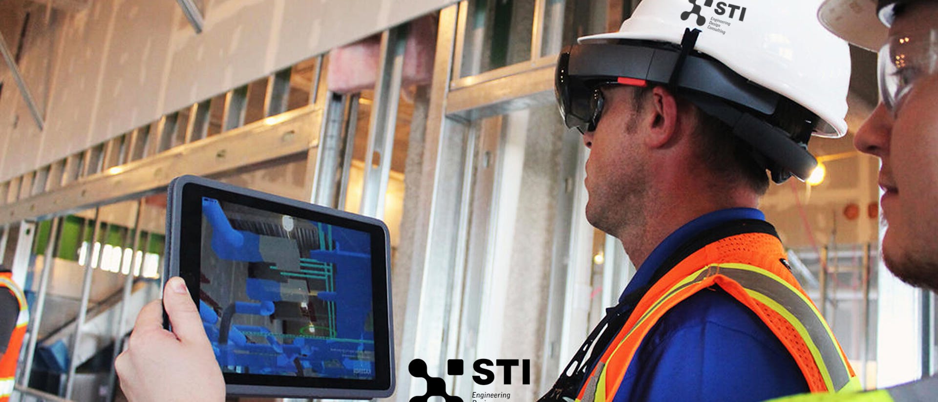
Through the Augmented Reality (AR) function, a hybrid dimension between the physical and digital worlds is returned to tablet / smartphone or Hololens, creating a visual overlap between the real, framed objects and the holograms of objects that have not yet been made. This activity is allowing for example to support the construction management in verifying the correctness of the installations on site.
Augmented Reality application on Smartphone with Dalux app
Thanks to this technology, the identification of problems occurs in advance and makes it possible to think about possible solutions to any problems that have arisen. Following the findings, dedicated Verification Reports are drawn up, which make it possible to assign the resolution activities of the problems detected. This operating mode allows to track the solutions adopted during the construction phase, facilitating the final production of an As-Built model faithful to reality that can be used in the Operation & Maintenance phase.
Another utility of the AR to be used both during the construction phase and during the maintenance phase is the ability to access the data that has been linked to the digital copy of the objects present in the Digital Twin model. This activity would make it possible to use all the documentation collected during all phases and obtain useful information as needed. At the same time it is possible to update the data contained in the digital objects with those detected in the field. This bidirectionality would ensure a constant update of information while keeping the Digital Twin model always active, especially during the use phase of the building.
Technicians surveying on site
Thanks to: Umberto Beneventano.
Did you like this article? Follow us for more content.